Monday, June 18, 2012

Journeys: Gallatin Peak - Day II

My alarm woke me up at 0400. The sky was still starry and black. I went back to sleep. My second alarm woke me up at 0430. My eyes fluttered open and I could see the western sky was still black. I rolled over and looked east. A crescent moon hung in deep blue skies just above and orange and yellow horizon. I had the idea that I was dreaming. I realized it was real and yelled at myself to get up and put my camera together to take photos. I took photos for the next hour and a half. It was a gorgeous secluded mountain sunrise.

Crescent moon and sunrise. Near Bear Basin.

I had to wear crampons to descend from the ridge into the basin. The snow was frozen and firm. I stopped at a stream in the basin to filter a few liters of water and ate breakfast. I continued through some trees and finally arrived at the base of the south face of Gallatin Peak. The slanted snow field I had chosen led up to a false summit. From there I would have to scramble 200 yards to the summit. I started up the snow field able to walk pied a plat 99 percent of the way. At the very top of the snow field the snow curled up to some rocks and I front pointed the last 10 feet of snow. I could see up to the summit and noted that it was a steep hike not even rock scrambling as expected. I looked down into the east bowl and immediately regretted hiking in from the North Fork trailhead. The east face snow field went from the base of the mountain to about 50 feet below the summit. I reckoned it would have been a more rewarding climb, but was happy to be up here. Maybe next time I will come in from Hellroaring trailhead and climb the east face.
Over the top and unnecessary hero pose - Gallatin Peak summit.
I slowly hiked up taking in all the scenery of the Spanish Peaks and beyond. I reached the summit and grinned. It was awesome. Soon the fattest chipmunk joined me and started nibbling at my pack. I took photos of the landscape then built a platform out of small rocks for my camera so that I could snap a self portrait. I hung around up top for a while eating and relaxing. I decided to explore the south ridge during my descent. I found that one could hike up picking their way around rock outcroppings and cliffs. From afar it looks to cliffed out to walk up. Back through the basin and up the other side to my camp where I had stashed unneeded gear. As I approached camp I spotted five or six big horn sheep euws traversing the ridge towards me. It seemed like that had no idea I was there, so I remained quiet and took a handful of terrible photos.

Fat chipmunk on Gallatin Peak.
Big horn sheep ewe above Bear Basin.
I took another long break at camp while I packed my gear and ate lunch. I descended from the ridge looking for safe snow to glissade on, but had no luck. I was in the bottom of Bear Basin and had six miles ahead of me. I hung my head and ground it out. I was exhausted. When I reached the trailhead parking lot and my truck I slumped to the ground my back against a tire. I wondered if I felt a tenth as tired as mountaineers coming off of a Himalayan summit.

Falls in Bear Basin.
Route up Gallatin Peak.


Friday, June 15, 2012

Journeys: Gallatin Peak - Day I


Still in search of snow climbs, I set my sights on Gallatin Peak. I had seen a large snow field on the east face from Wilson Peak and decided to do an over night backpacking trip to climb it. I struck out from the North Fork trailhead late in the afternoon with a heavy pack. I covered the first three miles in one hour. I covered the next three miles into Bear Basin in three hours. Getting up into Bear Basin takes more than a few switch backs over steep ground. Once in Bear Basin the terrain flattened, but I hit the snow line and travel was slow in the slush even with snowshoes. I reached the back of Bear Basin hoping to find clues of the trail heading up over the ridge to the northeast and through a pass into the basin south of Gallatin Peak. I found no clues. Instead I struggled, slipping and crawling, through wet snow up a steep rocky gully. I was spitting mad and tired. 

Near the top of the crest of the ridge I left the snow line and took my snowshoes off. I saw the trail ahead of me and followed it up onto the ridge. It was already after 8 p.m., I was tired, and from the ridge I saw that I had made a crucial mistake. To get to the east face of Gallatin Peak I would have to descend into the basin then hike three to four miles around Gallatin Peak's southeast ridge in order to get to the east face. I did not feel the need to push on through the dark and found a flat spot on the ridge to camp. As I ate dinner I picked a new route up a snowfield on the south east face of the peak. The sun was setting behind the head of Bear Basin. 

Shadows lengthened and the temperature dropped. I hoped that even in mid-June my zero degree bag would keep me warm through the night at close to 10,000 feet. I finished dinner and the sky was an inky blue and black. Near the zenith was Hercules and not far away the Big Dipper. I crawled into my sleeping bag and found the bivy sack coated with frost. I set my camera tripod up beside me in hopes of catching a nice sun rise in the morning and fell into a fitful sleep.

Thursday, June 14, 2012

Journeys: Beehive Peak II


Today I returned to Beehive Peak to search for an easier route to the summit from the 4th of July Couloir col. I camped in my redneck RV at the trailhead and got an alpine start, hiking before the sun woke up. The snow throughout the basin was firm and frozen and I did not need my snowshoes. At the 4th of July Couloir I strapped on my crampons and dug the spikes into the frozen snow. Climbing on the firm went much faster than the slush two days ago. Near the col I looked down and saw two snowboarders hiking up the basin. I passed the narrow couloir I climbed previously then went to the other side of the col and looked at a wider couloir. The second couloir was much wider and only had a short steep section in the middle. I was confident I could climb this couloir and find a way to the summit. 

The "easier" couloir.
Again the climbing was fast on the frozen snow and I front pointed up quickly until I reached a familiar rock section below the summit. I found my previous path and climbed to the summit. From the top I watched the snowboarders climbing on the east ridge while I snacked on trail mix. I wanted to descend before the snow softened and soon left the summit. I retraced my steps through the couloir and to the bottom of the 4th of July. The snowboarders were riding down from the east ridge and pulled up to stop at the bottom of 4th of July. I asked if I they were going to ride the couloir and if I could take photos. Their names were Addison and Mike and they agreed to some photography. We all hiked out and I went to work.

Addison Sponsler - shredding.
Mike Hudik - ripping.

Tuesday, June 12, 2012

Journeys: Beehive Peak


I climbed Beehive Peak today. Sometimes when you climb to the top of crag or a mountain you feel like you have conquered it. Today was not one of those days. Today felt like the mountain let me off the hook...this time.

Traverse over Beehive Peak.
I should have camped at the trailhead and got a proper alpine start. Instead I arrived hours late and started hiking up Beehive Basin just after 7 a.m. One mile in I saw a moose and her calf grazing on a grassy slope. No bears. Shortly after the moose I hit the snow line and put on my snowshoes. An hour and a half later I was in the bowl below Beehive Peak putting on my crampons. The snow was too soft for crampons, but I needed the practice. I cached my snowshoes and trekking poles under a small tree then started up the 4th of July Couloir, ice axe in hand. Climbing in the soft snow was slow and tiring. I am not sure how long it took to climb the couloir, but the view from the top was fantastic. I could see where someone had skied down the backside toward Beehive and Spanish Lakes. There may have been two or three small couloirs leading from the col to the summit of Beehive Peak, but I did not take time to assess each of them. I started climbing the one in front of me. It was a tight and steep couloir that tapered to what looked like (hopefully) 4th class rock.

Couloir above 4th of July Couloir.
The first few steps up were fine, but I was soon swimming in thigh deep sugar with my crampons bottoming out on rock. I was not comfortable with this and should have turned back, but stubbornly pressed on. The snow ended and I reached the 4th class rock. A rope and a partner would have been nice, but the crampon's spikes were quite stable on the rock and I climbed up passing a rat's nest of rappel anchors on the way.

I could see the peak. In between was snow and more 4th class scrambling. I started crossing the snow headed for the rock and realized I had left one couloir for the top of another larger one. I looked down the couloir and realized that I was now in a no fall zone with a fatal runout. The bottom of the couloir ended in thin air and the valley floor below. I made my way to the base of the 4th class scramble to the summit and removed my crampons. I had tried two different routes turning back when the moves were too committing before finding an easy route to the summit on the third try. The view from the summit was beautiful. To the north was Gallatin Peak, to the east Wilson Peak, and to the south Lone Peak and Fan Mountain. I spent a while eating and taking photos from the summit then packed up to head down the east ridge. I had heard that the east ridge was exposed 3rd class rock scrambling.

On the summit.
Looking at the ridge traverse from the summit. 
Looking back at the ridge traverse after finishing.
In snow it was treacherous. The sheer cliffs hundreds of feet down either side did not help my nerves, but I grit my teeth and made it to the descent gully below Honeycomb Peak. The descent gully was a gentle relief to the ridge traverse. Back in the bowl below Beehive Peak I took a long break and collected my nerves then made the hike back to the trailhead and my truck. As glad as I was to be out of a dangerous situation and finished with the climb I had a strong desire to go back for another round and see if I could find and easier way to the summit.

Friday, June 08, 2012

Journeys: Wilson Peak


I got my late alpine start for Wilson Peak and was hiking at 0655 from the North Fork Trailhead. Approximately 1.5 miles up the trail I crossed the National Forest boundary and immediately left the trail. I walked north and crossed the creek then picked up an unmapped trail up a spur into the drainage northwest of Yellow Mountain. I followed the trail past two rock outcroppings about 200 yards apart. The side hill was steep. I should have crossed the creek at the second rock outcropping, but crossed further up after the side hilling became extremely steep. Shortly I was in a clearing and could see directly up the barren avalanche slide path to the southwest face of Wilson Peak. 

Wilson Peak from the clearing.

I continued to follow the stream straight up the southwest face, which became extremely steep. Maybe 300 yards from the summit a whiteout snowstorm enveloped the mountain. I reached the summit in just under three hours. I took photos from the peak and then explored the saddle to the east that Kaya, Tanner, and I had seen a few days before. Unable to cross a large frozen snow field in the saddle, I backtracked to the West. I traversed out the ridge to another mountaintop at 10,3000-ish feet and took a break for photos and lunch. 


Pioneer Mountain, Cedar Mountain, Lone Peak, and Fan Mountain (L to R).

From this point I could see everything. Beehive Basin and Beehive Peak, Middle Basin, Bear Basin, Gallatin Peak, Hell Roaring Creek, Table Mountain, Wilson Peak, Taylor Peaks, The Sphinx, The Helmet, and Fan Mountain. I finished lunch and started my descent into Bear Basin. I followed slushy snow fields and glissaded as much as possible to save time and energy. I reached the stream under Mount Chipperfield and crossed it then picked up the trail on the other side. Three to four miles later of great single track brought me back to the trailhead. I relaxed for quite a while in my truck then went to work.


Looking back at Wilson Peak during the descent.

Friday, May 11, 2012

Journeys: Pacific Coast - Highway 101


     I was in the trailhead parking lot for Falcon Cove, OR when a surfer pulled up beside me. I thought it was a chilly morning and wondered how cold he would be in the water. The surfer said it was not too bad and totally worth it. I hiked a short way down to the beach and found more surfers. I studied the beach for a while then decided to hike two miles or so north to Falcon Point.
     The hike was mucky. I bushwhacked down a drainage in search of a waterfall, but turned back when the vegetation became too dense. At Falcon Point I enjoyed sitting atop sea cliffs and watching the waves crash. Sea gulls swooped overhead. On my return to Falcon Cove I came upon a small waterfall down a side trail. I took a few photos there then followed the drainage until it cliffed out just above the beach. There was another waterfall crashing down to the beach's tide pools from the cliff I was standing on and I decided to take a photo of it from the beach.

Waterfall above Falcon Cove, OR.
Waterfall spilling into Falcon Cove tide pools.
     I got the waterfall photo from the beach then returned to my truck. I drove a mile or two up the road to where there was an overlook looking down on Manzanita, OR. It was a great view and I stopped to have lunch and relax from the morning's hike. While lounging, an older gentleman called out, "Whale!" from the edge of the overlook. I dashed to the stone retaining wall. Sure enough, there was a whale and her calf surfacing for air. Then they sank back into the dark sea and continued north along the coast. I packed up and continued south to Tillamook. I saw on the map that there was a lighthouse at Cape Meares State Park and thought it might make a nice photo.
     The view at Cape Meares was great, but the lighthouse was small and there were no good angles for a photo. I was content to stroll around and look down upon Three Arch Rocks National Wildlife Refuge where seals, sea lions, and tuffins hung out. I drove further south to Oceanside, OR and had a short stroll on the beach. It was late afternoon and I decided my time on the coast was up and I would head for Portland to visit a friend.
     Once in Portland and connected to the internet, I discovered I only had enough gas money to drive straight to Bozeman. I did just that two days later ending my trip to the Pacific Coast and Highway 101.

Thursday, May 10, 2012

Journeys: Pacific Coast - Highway 101


     It was morning and I was on the road again, finished with the beaches at La Push and Mora. Gray storm clouds were scattered along the coast, some were raining others were threatening. I thought it might be a poor day for landscape photography and was fortunate to find tide pools thriving with wildlife at Ruby Beach. I hiked around in search of the most interesting cluster of green sea anenome and ochre starfish. A dark cloud moved in and it started to rain. I returned to my truck and drove further south. I made a quick stop at Big Cedar, literally a giant cedar tree. It looked as if four massive cedar trees had grown out of one stump. There was an arched opening at the base of the tree and three or four people could have easily used it for shelter. My next stop was First Beach of Kalaloch, WA. First Beach was wide and sandy and stretched north past Kalaloch all the way to Ruby Beach. I hiked from First Beach to Kalaloch Rocks and back to my truck. I took one photo of a washed up rope that wonderfully contrasted the sand and the sky.
Tide pool marine life at Ruby Beach, WA.
Washed up rope at Kalaloch Beach, WA.
     I had no plans of further stops on the Washington coast as I drove south to Oregon. After leaving the Olympic Peninsula the vegetation thinned and I could more often see from the road the flat sand beaches stretching for miles and miles. I stopped on the north side of Gray's Harbor to stretch my legs and walked out a long jetty to photograph waves crashing. These were my last photos in Washington. Soon I was in Astoria, OR in desperate need of a beach to watch the sunset. I stopped in at a gas station and asked the attendant for advice. She recommended Canon Beach a few miles further south. There I could find Haystack Rock and other sea stacks. The golden hour was upon the landscape and I was frantically searching for parking at Canon Beach. Haystack Rock and its smaller sea stacks were excellent scenery and I now know that the rock is a well known place to take photos. The sun was setting and once again I was running to get to a good spot in time. I posted up near a Korean man from Hawaii and his wife who were also taking photos of the sunset. We talked of there vacation and my road trip. The sunset was finished and I returned to my truck to cook another tailgate dinner. I had no idea where I would sleep...again. Eventually I found a wide spot on Highway 101 without any "No Camping" signs.

Canon Beach, OR sunset.

Wednesday, May 09, 2012

Journeys: Pacific Coast - Highway 101

     It rained during the night. I slept extremely well for the first time in two nights and decided to sleep in as long as possible. I had breakfast and was back at Rialto Beach by 10:30 a.m. I was looking forward to the day's hike and set off. I had the idea to hike to the Chilean Memorial near Cape Johnson where the map indicated there might be a nice cove. About a mile into the hike I came across a headland and a feature named Hole in the Wall. The Hole in the Wall was not so much a hole, but a window through the cliffed out headland looking upon the ocean. It struck me as a piece of natural beauty and thought it would glow nicely in the evening sun. Shortly after Hole in the Wall the hiking changed from sandy beach to headland rock scampering. I came across an older man resting on a rock. He had a Nikon camera and was wearing a silver watch. I asked him how his day was and what he thought about the cove that I was destined for. He recommended a point just south of the cove where he enjoyed taking photos of mussel and kelp beds. I looked out to the ocean and only saw a small island with two miniature mountain peaks connected by a saddle. Where was the point? Oh, the island was the point. The point was connected to the beach by a line of rocks accessible when the tide was out. It was 2:00 p.m. The tide was due in at 4:30 p.m. I debated my odds of being stranded with the old man. He thought I would surely and unfortunately be stranded. I agreed, but replied that it was all part of the adventure then set off directly for the point.
     I reached the rocks leading to the point and began hopscotching my way out. I was standing on a rock halfway to the point when I stopped to take a look around. Lapping water broke my wandering thoughts and I realized that the tide was coming and the passage to the point was closing. Exciting! I  leapt from rock to rock reaching the point in time to turn around and watch my exit disappear under water. It was 2:20p.m. The tide would be highest at 4:30p.m. I wondered how long I would be stranded on the now island, but pushed those thoughts aside and started exploring. I scrambled 50 yards up the steep saddle linking the two miniature mountain peaks. The slippery rocky slope rewarded me with one of my favorite views and photos of the entire road trip.


View from the island/point.
     I lounged in the saddle laying in the grass enjoying the view. It was rather windy in the saddle and soon I was cold. I down climbed to the rock and sand beach lining the perimeter of the island and walked to the west side of the island. There were a few small rock pinnacles and I had some fun killing time and climbing to the top of each one. At the top of the highest pinnacle I sat and watched a small boat bobbing in the waves out past the furthest sea stacks. The waves were so big that each time the boat was in a trough it would vanish from sight! I traversed out a band of rocks away from the island as far as I dared and took photos of crashing waves. I was hungry and clambered up the side of the island to a sheltered spot and had lunch. After lunch I returned to the east side of the island and took a nap on a rock. When I woke it was 6:00 p.m. and the island was starting to block the sun. It became quite cold. My exit was still completely covered in water. I returned to the saddle and sat in the sun trying to stay warm. The wind in the saddle drove me away again and I returned to the beach and stood by the closed exit jumping up and down to stay warm. I could see the tops of rocks re-emerge from the water as the tide slowly went out. It was like watching paint dry. Around 7:30 p.m. I took my chances and started skipping across rocks just poking out of the water. I was 50 yards out when the water surged recovering my escape. Water spilled into my boots and I was immediately soaked. Frustrated I looked at my feet and cursed the ocean. When I looked up again still standing in ankle deep water I saw a sea otter swimming on his back staring back at me. Was that rock on his belly? Seeing the otter lifted my spirits. The surged went out and I hopped my way back to the mainland.
     The sun was sinking and the golden hour was fast approaching. I was far from Hole in the Wall and started to run. I ran all the way to Hole in the Wall and good thing too for I made it just in time. I took photos as the sun glowed on the rock making quite an image. Surprisingly exhausted from laying around on an island for five hours I made it back to my truck and returned to my random trailhead parking lot for the night.


Hole in the Wall catches the evening sun.
HDR sunset near Rialto Beach, WA.

Tuesday, May 08, 2012

Journeys: Pacific Coast - Highway 101


     I jerked awake. Pale morning light was just illuminating the trees around my truck. I turned the key and fired up the engine breaking the silence of the dense forest around me. It was four miles of winding dirt road to the top of Mount Walker on the eastern edge of the Olympic Peninsula. I was searching for a good angle for a sunrise photograph. The summit of Mount Walker had two lookouts. Neither provided the view that I needed for the sunrise. Disappointed I quickly and recklessly drove down the mountain and south on Highway 101. I found a pull out by the water of Dabob Bay and took a few photos of the sunrise. Not the sunrise over a distant Seattle I wanted, but it was still beautiful to watch the sun wake the world up.
Sunrise over Dabob Bay, WA.
     Today I would start the meat and potatoes of the road trip, driving Highway 101. From Mount Walker I would drive along the north coast to Neah Bay. From Neah Bay I would turn south and search for scenery on the west coast. I had grown accustomed to the sweeping valleys and mountain ranges of Montana and was hampered by the dense vegetation that choked either side of the highway as I drove along. The occasional clear cut would provide the narrowest of vistas. The first town of note I came to was Port Angeles. I had this vision in my head that I would be hopping from quaint fishing town to quaint fishing town, each perched on a cliffy cove overlooking the crashing sea. Towns peppered with pastel houses clustered on rocks and beaches where fishing boats motored back and forth. Port Angeles was not the town I sought. It was industrial and unappealing. After Port Angeles I passed a road sign for Crescent Bay and Salt Creek and decided to pull off to investigate. Crescent Bay was shaped in an appealing crescent, obviously, and there was a nice sea stack on the east side. I hiked around for a bit taking a few photographs then returned to my truck. Exhausted from poor sleep the night before I unintentionally fell asleep in the driver's seat while looking at a road map. I awoke a full two hours later. The parking lot had been empty when I arrived, but now it was full and there were many people out walking. I finally had some breakfast on my tailgate and finished looking at the road map. A man parked beside me agreed that I should head to Neah Bay.
     It was a twisting slow drive. The route actually leaves Highway 101 for 112 which brings you to Neah Bay and Cape Flattery, the westernmost point in the contiguous 48 states. As I was driving 112 overlooking the north coast I again had visions of a quaint fishing village to be found in Neah Bay. Although there were fishing boats, all docked and lazily bobbing, Neah Bay was run down. What caught my eye the most were all the handmade "don't do meth, booze, or teen pregnancy" signs tacked up on light poles. I stopped in at the Makah Tribe's museum and purchased a recreation permit so that I could visit and hike to Cape Flattery. If I had been disappointed by the lack of quaint fishing towns along the north coast Cape Flattery was the diamond in the rough. The hike was short and the view breathtaking. The cape ended at the sea in steep and dramatic cliffs with waves crashing against the rocking releasing hollow booms. My adventurous side wanted to find a way to the bottom of the sea cliffs, but I stayed on the trail and took photos from the designated view points.
Looking south from Cape Flattery.
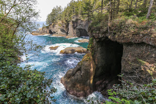
Sea caves at Cape Flattery.
     Back in the parking lot I cooked lunch on my tailgate and planned my next move. I still was not sure of any specific destinations on the coast and decided I would drive down to Forks and find a place to ask for information. Other than being the home of the Twilight novels, Forks is just another non-quaint coastal town. They did have a grocery store and an Ace Hardware store where I stopped in to talk to one of the cashiers about the Forks area. Nathan was very helpful and pointed me to the first, second, and third, beaches of La Push and Rialto beach of Mora. It was only about one hour until the golden hour and the sunset and I decided to drive to the beaches of La Push. 

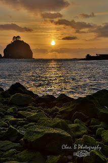
HDR sunset at First Beach, La Push, WA.
     On the way I discovered that the third and second beaches required hiking and I did not think I could make the hikes before the sunset. I drove down to first beach, which required no hiking, and parked next to an old man looking for whales with a pair of binoculars. The man suggested I hike north from Rialto Beach the following day. I tiptoed around on the jetty guarding First Beach looking for good angles. A large island and a few sea stacks just off of the beach providing a nice foreground for a Pacific sunset. A seal surfaced beside the jetty and snorted at me. The seal continued to play by the jetty and I continued to look for that magical angle. Satisfied, I returned to my truck and ate some food while preparing my gear and waiting for the sun to sink further. The sun was nearing the horizon, but had yet to really blaze the sky with color. I returned to the jetty and composed a few shots for an HDR showing the green seaweed on the rock in the foreground. I climbed back up to my tripod at the top of the jetty and bumped into another photographer. He was an older gentleman staying in a nearby RV park. We chatted and snapped photos. The sunset was gorgeous and I was starting to really like the coast despite the salty air. With the sun asleep I realized I still had no place to sleep. Skunked at Rialto Beach, which had obvious "No Camping" signage I settled for a random trailhead somewhere in further inland in Olympic National park.

Monday, May 07, 2012

Journeys: Pacific Coast - Highway 101


     Paul and the other boys of the house were up early. I found no sleepy solace on the couch in the living room. After breakfast at Betty's Diner with Paul I returned to the house to edit photos and research destinations in the Pacific Northwest. Editing went well, but research went poorly. Maybe "scenic places in Washington" or "Washington photography" were the wrong query strings to plug into Google. I left Polson bound for somewhere on the Olympic Peninsula. 
     I took the scenic route from Polson to Coure d'Alane, ID through Thompson Pass, MT. It dawned on me while I was driving up to Thompson Pass - mainly because of posted signage on the roadway - that the pass may still be snowed in and might have to backtrack 30 miles to get back to I-90. The pass was open. I was back on I-90 in eastern Washington and the landscape transformed into desolate flat farmland. Hours later I caught sight of still snowcapped Mount Rainier towering in the hazy blue sky. To north I could make out a jagged mountain range and directly in front of me was Snoqualmie Pass. Once over Snoqualmie Pass the traffic intensified and suddenly I was in Seattle. I frantically checked the map while keeping an eye on the road and somehow wound up going the right way, south to Tacoma. Night fell as I left Tacoma for Bremerton. At 10:30 p.m. I was stopped with other motorists at a drawbridge over the Hood Canal. We did not move again until 11 p.m. By the time I hit Highway 101 I was exhausted. I drove south into Olympic National Forest and pulled into a trailhead parking lot. It was after midnight. I promptly fell asleep in the driver's seat.