Summer has faded and soon the snow will start to fly in the short shoulder season of autumn. This leaves a small window for me to make the final push on my biggest hike of the warm season - the summits of Sphinx Mountain and its neighbor The Helmet.
The standard approach for these two summits joined by a saddle is a 10 mile roundtrip hike from Cameron in the Madison River valley. Unfortunately for me and my wallet, Cameron is a 200 mile roundtrip drive from Big Sky. Not wanting to spend the gas I luckily drew up another route to these two gems of the Madison Range. Unluckily, my chosen route from the east would be a 32 mile death march starting at the Buck Creek Ridge trail head.
And that is where I found myself at 8:30 a.m. on Saturday morning. Sitting in my truck not really sure I was ready to throw myself into this foot and knee bashing back breaker. It had rained during the night and part of me was begging for the skies to open up again giving me an excuse to bail on the adventure. No such luck. I found the courage to exit my truck and began walking.
The first 6.4 miles of the hike were a gently rolling, but exposed ridge top - a bad place to get caught in a storm. After 45 minutes of walking I decided to pick up a light jog feeling I should make the best time I could while the terrain was forgiving. After 90 minutes on the trail I arrived at the First Yellow Mules trail junction, my first landmark on the hike. I took out the map and rechecked the next few junctions; there were three I had to pay close attention to in the next mile. The first important junction was 0.4 miles from where I stood.
A mile later I knew something had gone wrong. I was still jogging and had covered too much ground too fast bringing me to a junction with the Yellow Mules Cabin trail. I pulled the map out again. I was a mile west of a left turn I was supposed to have made to go south into Mcatee Basin. I was frustrated. I had kept my eyes peeled, but had never seen the trail junction or any trail headed due south into the basin. Not wanting to retrace my steps back a mile and sniff out some confusing slightly hidden trail I pored over the map in search of an alternative. And there it was, the solution. All I had to do was keep walking a mile out Buck Creek Ridge then simply sidehill around a knob south into Mcatee Basin where I would pick up Mcatee Trail. I would follow this trail for two or three miles to Middle Fork Bear Creek Trail, which would take me to Helmet Saddle Trail and the summits of Sphinx and Helmet.
The plan was in place and it was time to execute. I jogged the one mile out Buck Creek Ridge then dropped south off trail into Mcatee Basin. I would not see a trail again for three miles. Mcatee Trail was on the map, but not in the dirt. If the basin had been more rugged, not having a trail would have been much more frustrating. But it was a gentle roller through shrubs and tall grass. The fall foliage helped to accentuate an already grand view of Sphinx. The west end of Mcatee Basin spit me out down a steep headwall into the Middle Fork Bear Creek drainage. Hiking through trees and denser vegetation, I hoped to soon find the trail on the flanks of Sphinx.
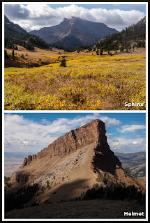 |
| Sphinx and Helmet. |
When I did I started jogging again feeling I had lost far too much time off trail in Mcatee Basin. It was all downhill to Helmet Saddle trail and scenery flew by in a blur. I turned left and started up towards Helmet when a cow moose jumped up about 20 yards from me giving me a nice shot of adrenaline. The trail zigzagged in gentle switchbacks up a wide grassy slope to the base of Helmet and into the saddle connecting Sphinx and Helmet.
All along my plan had been to climb Sphinx first. I reckoned that since it was the bigger of the two Sphinx should be climbed first in case I ran out of time and had to leave without doing Helmet. BUT something in my gut told me to go for Helmet first. I have no idea why, but I followed my gut and was soon traversing under the south face of Helmet. At the far west end of the formation I scrambled up a dirt gully then climbed over a chockstone. This gave me passage to the gentle grassy west slope that was easily hiked to the summit.
I took a photo using a small tripod and the point and shoot making sure to get the west slope of Sphinx in the background. I ate Pop Tarts then started back down to the dirt gully.
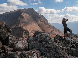 |
| Summit of Helmet. |
I traversed back to the saddle then picked up the faint summit trail up Sphinx. The summit trail eased up the grassy west slope of Sphinx picking its way through rock ledges to the primary drainage off the slope. The trail continued straight up the loose and slippery drainage to the summit ridge. I passed a few hikers who where on their way down and exchanged "hello's".
Finally I was on the summit standing next to a large rock cairn. It might have been 2:30 p.m., much later than I wanted to make the second summit. The weather seemed fine and I had no intention to linger on the summit, which offered a magnificent view from the heart of the Madison Range. To the north was Lone Peak and the Spanish Peaks. To the south the Taylor Peaks and maybe somewhere in there, Hilgard Peak. As relieved as I was to have summited both mountains, I knew I was only halfway done and had 16 long miles to get back to my truck at the trailhead.
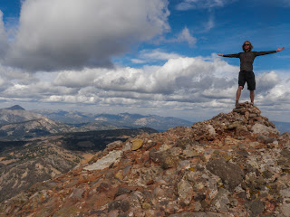 |
| Summit of Sphinx. |
I ran off of the Sphinx and all the way back down to Middle Fork Bear Creek trail. I wanted to keep running, but my legs refused. That "legs of stone feeling" started to set in and I walked as quickly as I could back up the drainage. As I neared the pass into Cougar Creek the trail became intermittent and I was worried that I would be forced to bushwhack again killing any good time I was trying to make.
Luck was with me and the trail became more apparent over the pass move quickly for two miles to the trail junction at the east end of Mcatee Basin. This half of Mcatee Trail was in the dirt and I followed it to the junction with Inspiration Trail Hookup. A one and three quarters mile climb put me back on Buck Creek Ridge. I was supposed to come out on the trail I had missed earlier in the day and soon found why I had missed it. Once again, there is a trail on the map, but no trail in the dirt. Two tenths of a mile of a nonexistent trail indicated by two small cairns had been the crux of the morning. But now I knew what to look for the next time.
I felt like I had the hike in the bag. 6.4 miles of ridge top trail that I had already hike was all that stood between me and my truck. I tried to jog, but my legs still refused. I walked on and on still trying to run in spurts. My entire body begged me to sit down for just a few minutes, but I was afraid to lose time and get caught in the dark.
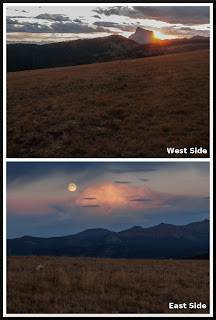 |
| Sunset views from Buck Creek Ridge. |
It was all for naught and soon I was hiking in the dark.
Once darkness fell I broke out my headlamp and had to take my prescription sunglasses off. I had no clear lens glasses and the trail was now a fuzzy tan. I could only hope no rocks or roots would trip me up. I was laughing to myself that it could be worse. I could not be that far from my truck and would only half to suffer with the poor vision for a few minutes. Then it started to rain. And it was not one of these gentle drizzles I had seen or been in during the summer. The kind that spit for two or three minutes kicking up that peculiar dirt smell in the air. No, it hammered down. It was cold and I could have gotten my rain jacket out, but was too stubborn to stop convinced that I was only a hundred yards from my truck. 20 minutes later I arrived at my truck, drenched, cold, and smelling like a wet dog.
An epic ending to the biggest hike of the summer.


No comments:
Post a Comment