Friday, August 12, 2011

Journeys: SEND IT - August 11th - Ohio/Baltimore, MD

SEND IT is over. It only took four hours to get from Ohio to Morgantown where I dropped Beth Ann off. It seemed like I had picked her up just the day before, not five weeks before. What an incredible journey. It was just me and reflection for the next three hours back to Baltimore. What a trip it had been. I have no words to describe it all.

Awesome.

Total money spent on gas = $1555.27
Total miles driven = 7552.7

Mileage.

Journeys: SEND IT - August 10th - Pierre, SD/Ohio

We had a big day of driving ahead of us since we left Devil's Tower so late the evening before. I hoped to make it from South Dakota to Ohio, roughly 1,000 miles of driving, before we stopped to sleep again. From Ohio it would only be eight or so hours back to Baltimore. We drove and drove and drove and drove. Back through Iowa, Illinois, and Indiana we went. The sun again sank below the horizon and we were hurtling down a dark highway. Everything was a blur. My mind was numb. We had covered so much ground, climbed so much, had returned to the wilderness. It had been epic, awesome, it had rocked. And now it was all over. Our bodies now adjusted to waking to the sun warming our faces would have to readjust to dark bedrooms and alarm clocks. Instead of eight hours of climbing each day we would do eight hours of studying or eight hours of "work". A big part of me did not want to go home, but I knew it was the right thing to do. Just give it some time Charlie, then you can move out west for good. Ah, that thought will be the light at the end of the tunnel. To one day move to a place where so much outdoor satisfaction can be had is truly inspiring. I cannot wait. Finally, Ohio. At 0030 we pulled into a rest stop between Dayton and Columbus and were soon fast asleep in the truck.

Journeys: SEND IT - August 9th - Devil's Tower, WY

I was out of bed and packing up at 0600. Rain moved in at 0630. It sprinkled for just a second, but dark clouds continued to gather all around Devil's Tower. I was worried. I checked the weather map repeatedly and it showed that a significant rain storm was over our heads and another would be on its way later in the day. Climbing in the rain would be impossible for us.

Rainbow over Devil's Tower.
Photograph by Chuck Bolte.

Somewhat dejected we pushed the rest of our camping gear into the back of the truck and drove from the KoA to the Devil's Tower visitor center parking lot. From 0715 to 0745 it rained harder then stopped. We waited in the truck for an hour to see if the rain would continue. No more rain fell, so we registered as climbers and started the approach to the Durrance Route. We followed the approach in the guide book, which does not clearly reveal that the traverse across the southwest shoulder is a long exposed fourth class scramble that is terrifying when wet from rain. We actually roped up for the last 100 feet in case one of us slipped. It was already a long way down at that point and we were not even on the route. Once we were both at the bottom of the Leaning Column I soon realized that the Durrance Approach is not the best way to go. It would be much easier to walk to the bottom of the Meadows Rappel route then rope up for what looked like 100 feet or so of 5.0 climbing. I also noticed that we could easily traverse to the base of the Durrance Route from the rappel anchors at the top of the last rappel on the Meadows Rappel. This allowed us to stash our packs and extra gear under a stunted pine tree at the base of the leaning column. The Durrance Route is rated at 5.6 and I quickly found out that it would be the hardest 5.6 I have ever climbed. Having not climbed many off widths and chimneys in my short climbing career, the climb was extremely difficult, especially the first two pitches. The second pitch was definitely the crux for us and I was definitely cussing before we reached the third pitch, Cussin' Crack. The second pitch had two parallel cracks. On the right an off width for chicken winging and jamming the right side of your body and on the left a hand crack for your left hand and left foot. I took many rests. It was extremely demanding. Beth Ann also felt that it was very challenging. At the belay at the top of the second pitch I could only hope that there was no more of that to come. Fortunately the route did mellow somewhat through pitches three through five.

Last move of pitch three.
Photograph by Chuck Bolte.

At the top of pitch five after pulling through a smelly bird poop cave we had to make the decision of whether or not we would traverse to the Meadows the scramble 140 feet to the summit or simply climb straight up on the Bailey Direct finish above our current belay. The Bailey Direct seemed less complicated to me and a better way to climb the tower from top to bottom, so we finished with the 150 foot final pitch over mostly easy terrain with two bold moves on it. As Beth Ann started to follow the final pitch, the second rain cloud that I had seen on the radar earlier in the day crept up over the tower and started raining. I heard a distant clap of thunder and my shoulders sank. Here we were 10 feet from the top of a 900 foot tower, exhausted, getting soaked in rain, and now lightning threatens to strike our metal laden bodies down and permanently end our road trip on the very last day of climbing. Beth Ann finally made it to the belay as the rain increased then she climbed the final 10 feet to the summit. I scrambled up and we took hurried summit photos before hustling to the top of the Meadows Rappel.

Beth Ann's hero pose.
Photograph by Chuck Bolte.

Chuck's hero pose.
Photograph by BA.

Thunder continued off in the distance, but fortunately there was no lightning close to us. We hurried down the first rappel pitch into the Meadows then traversed to the next rappel station. Three LONG rappels later we were on the ground with our packs. My legs hurt. The stemming and chimney-ing had taken quite a toll and I could not wait to get to the truck and drop my pack.

South east side of the tower.
Photograph by Chuck Bolte.

Durrance Route (starts at base of obvious right leaning column).
Photograph by Chuck Bolte.

We hurried away from the tower, thankfully the rain had stopped, past gobs of bikers taking pictures of the tower. One man shook our hands and congratulated us. We turned in the second half of our climbing registration form stating that we had reached the summit and that was it. The final climb of the trip was over. It had not been the most fun route of the trip and it was impossible to enjoy standing on top of Devil's Tower, but we had done it. It was much later than expected when we pulled out of the parking lot. 1800 if I remember correctly. We got in a few hours of driving arriving at a rest stop outside of Pierre, South Dakota where we slept in the truck for a few hours. Tomorrow we continue on our drive back to the east coast, back to the daily grind.

Journeys: SEND IT - August 8th - Bozeman, MT/Devil's Tower, WY

We were in no rush to leave Montana, but still arrived at Devil's Tower plenty early. As we entered Wyoming I kept my eyes glued to the horizon, expecting to see the tower looming in the distance. I was finally rewarded once we had turned off of the interstate and were heading north on route 14 east. Like City of Rocks, Idaho, Devil's Tower seems to be a freak of nature. Flat prairie stretches for miles in all directions, then suddenly a huge 900 foot tall rock tower shoots up from the prairie floor like an eternal prairie dog. We pulled into the KoA and camped with masses of bikers bound for the huge motorcycle rally in Sturgis. As I lay in the tent reading while the sun went down, I could not help, but to be shocked that tomorrow was the last climb of the trip. The past four weeks had flown by and we would soon be back on the east coast, back to the daily grind. This has been a special trip.

Journeys: SEND IT - August 7th - Bozeman, MT

Today was a lazy rest day. I did laundry then Paul, Beth Ann, and I all went into downtown Bozeman, rented bicycles, and cruised around the Sweet Pea festival. Then, we went over to Belgrade for our final and Paul's birthday dinner in Belgrade. Tomorrow we head to our final destination and last climb, Devil's Tower, Wyoming.

Sunday, August 07, 2011

Journeys: SEND IT - August 6th - Bozeman, MT

Today Beth Ann and I were back in the climbing saddle. I had picked up the Bozeman climbing guide two days before while touring downtown Bozeman and had picked out Bozeman Pass based on a local's advice. Specifically we were headed to the Fat Man wall. It was roadside cragging at its finest. An ample pocket of bolted climbs literally a stone throw from I-90 six miles east of Bozeman. The approach was a mostly flat 0.7 mile jaunt parallel to the interstate. Fat Man wall was west facing and in the shade for most of the time we were there and when the sun did creep around the wall there were plenty of shade trees to hide under. With one 5.8 and many more 5.10s Fat Man made for a great sporty climbing day. The rock was peppered with finger pockets and jugs making up for the "steeper than it looks" pump fest. We threw ourselves into the thick of it climbing the jugs until we were just to tired to hold on.

Beth Ann on Nagasaki.
Photograph by Chuck Bolte.

Beth Ann on Duck and Cover.
Photograph by Chuck Bolte.

Beth Ann on The Natural.
Photograph by Chuck Bolte.

I really thought it was a great place to climb. Plenty of shade in the morning, an easy approach, and great features leading to challenging moves and tests of strength. Tomorrow we continue to relax, do laundry and prepare for our final destination and climb, Devil's Tower, Wyoming.

Journeys: SEND IT - August 5th - Bozeman, MT

Today we drove through Yellowstone National Park, acting the tourist, and hitting all the classic stops. Loads of driving brought us through the beautiful park, past geo thermal activity, to Old Faithful, and Lower Yellowstone Falls. I had hoped to see a bear, but only saw buffalo, elk, and a coyote. Enjoy the pictures!

The Madison River.

A cyclist.

A tree fell down.

Ranger talk.

Old Faithful.

Blurry elk.

Lower Yellowstone Falls.

Blurry buffalo.

Journeys: SEND IT - August 4th - Bozeman, MT

We arrived in Bozeman yesterday evening. We had taken highway 20 in from Idaho and amazingly got a long glimpse of the Tetons miles and miles to the east in Wyoming. We passed through tour-isty West Yellowstone and drove the length of the Gallatin Canyon passing Big Sky and Moonlight Basin ski resorts where I had snowboarded in early 2010. It was good to be back in Montana, big sky country. We did not have much of a plan for Bozeman, but I wanted it that way. I just want to laze around for a day, see Yellowstone another day, climb one day, laze another day, then head to Devil's Tower. Today we got in plenty of lazing. We enjoyed downtown, bustling with the Sweet Pea Festival 2011, then drove all the way up to Big Sky and Moonlight Basin for a late lunch and to see the beauty of the resorts sans snow. It was a scenic afternoon up in the mountains with no snow. No botched approaches, no unforgiving routes. Just a day of relaxation to regroup and rest.

Journeys: SEND IT - August 3rd - Salt Lake City, UT/Bozeman, MT

After talking with my friend Paul in Bozeman, MT, our next stop on the trip, we decided we would leave for Bozeman on the afternoon of the 3rd instead of the morning of the 4th. Paul had taken time off of work and wanted to maximize his days off. We would not leave Salt Lake City without climbing though. We headed to a popular roadside crag in Big Cottonwood Canyon called the Salt Lake Slips, where had another mini epic before we even started climbing. The SL Slips are located near the same pull out for Dead Snag and Glass Ocean, but is on the north side of the creek and in about 25 yards. The guide book urges climbers to take extreme care in crossing the creek since people have been swept away and drowned in the past. On my initial look I could find no viable crossing and started to search for other avenues of approach. If we drove down stream a quarter of a mile we would cross a bridge putting us on the same side of the creek as the Slips. It looked like if we parked at the bridge we could simply walk upstream and get to the Slips. We parked, walked, and were dismayed when we came to a rock outcropping, the Creekside Crag, that offered not an inch between rock wall and raging white water. We delicately scrambled up and over the rock with the water 20 feet below us and found bolted anchors at the top of a climb on the east side of the wall. We tediously rappelled down repacked the rope and walked on. We did not get very far. The gully between Creekside Crag and the Slips was much larger than I thought, It was also steeper, looser, and more choked with vegetation than it needed to be too. I was cursing again. Falling my way up a steep dirt slope, then bushwhacking my way through dense saplings we finally came to the top of what I hoped was the Slips. I found a set up bolted anchors, which were the top of a two pitch sport climb on the Slips called the Italian Arete. I flaked out the rope for the rappel and ran it through the rappel rings, then clipped my cowtail into the anchors and got ready to swing over the lip of the top of the cliff. As I was peering over, my foot caught probably the only loose rock at the top, sending it skipping down the face just as a climber was topping out of the first pitch on a ledge below us. "Rock!", I yelled. The climber blankly stared up at us. It was a slow motion moment. The rock's initial descent was away from the climber, but after two skips off the face it was tracking directly towards him. I had time to yell, "Watch out bro!" He sort of turned his head and the rock glanced off of his right shoulder. I felt like a total piece of [insert derogatory word here]. We rappelled and once on the ground I apologized ferociously. The climber was uninjured and forgiving. This had been the worst approach of my time as a climber. We had crawled for an hour over a quarter mile of terrible terrain to get to a wall 50 yards from the road and then I hit another climber with falling rock. I did not want to climb. I just wanted to leave. Big Cottonwood Canyon had taken its toll on me these last two days. Fortunately, I was able to put aside my completely bruised, broken, shattered ego and knock out some enjoyable sport climbs at the Slips.

Beth Ann climbing at the SL Slips.
Photograph by Chuck Bolte.

When we ran out of time and had to pack up, we asked some other climbers if there was a faster way back. They told us there was an easy creek crossing just at the end of the crag. There sure was. A single strand of webbing tied between two trees spanned a shallow part of the creek, providing the needed security to overcome the swift, cold current.

Beth Ann. Cold. Very Cold.
Photograph by Chuck Bolte.

We were back at the truck in 10 minutes versus the the hideous hour long approach, which somewhat lifted our spirits as we left Salt Lake City bound for Bozeman. Big Cottonwood Canyon had done its damage, yet I cannot wait to return and again face the demons that were so cruel to me. The lure of climbing is undeniable.

Journeys: SEND IT - August 2nd - Salt Lake City, UT

The Glass Ocean Nightmare (a mini epic adventure in Big Cottonwood Canyon)

I woke early, but lazed for an hour, taking care of internet business. I eventually thought to wake Beth Ann and eat breakfast. We left Matt and Wendy's house by 9 a.m., our destination was Big Cottonwood Canyon and the tick list included routes in the Dead Snag Area, Glass Ocean Wall, Challenge Buttress, JHCOB Wall, and the Salt Lake Slips. We would not climb past the Glass Ocean Wall.

The rain clouds had blown out during the night and the pavement was dry as we made our way up the winding mouth of Big Cottonwood. The nice thing about our climbs today were that they were close to the road and the approaches were short compared to the hour long approach to the West Slabs of Mount Olympus. We would start with Steort's Ridge, a moderate trad route in the Dead Snag Area. We parked the truck and followed the approach instructions in the guide book. Up a slight hill to a trail to the right. Cross a stream. Walk a short distance and arrive at the bottom of the climb. As we walked in we saw another party topping out and the no one else was waiting to start the route. Perfect timing. We stacked the rope, did our buddy checks, and I was off on the lead. Forty feet off of the deck pulling through an overhang I wondered to myself, "Maybe I do need some smaller cams". There had been a few horizontal cracks that were questionable stopper placements, but would have accepted a small cam. I had fished some stoppers in the horizontal weaknesses, but realized they probably would not have held a fall and would have only been mental protection. Small cams would have been nice. So, I had run it out. The overhang was not too hard. I just had to take a deep breath and look at the moves. Finally I cranked through where I was rewarded with a ledge and some pro placements. Shortly after the overhang, I built a belay and Beth Ann followed. I think the route was mean to be done in two pitches, but we split it into three. I have grown tired of pitch after pitch of not being able to see or hear my belayer during this road trip. Since this rock canvas was my own to paint on, we made three pitches to remedy communication problems. We chugged through the second and third pitch. These two pitches did have plenty of exposed, yet easy arete climbing, making the route very enjoyable and a great way to start the day.

Beth Ann tip toeing up Steort's Ridge.
Photograph by Chuck Bolte.

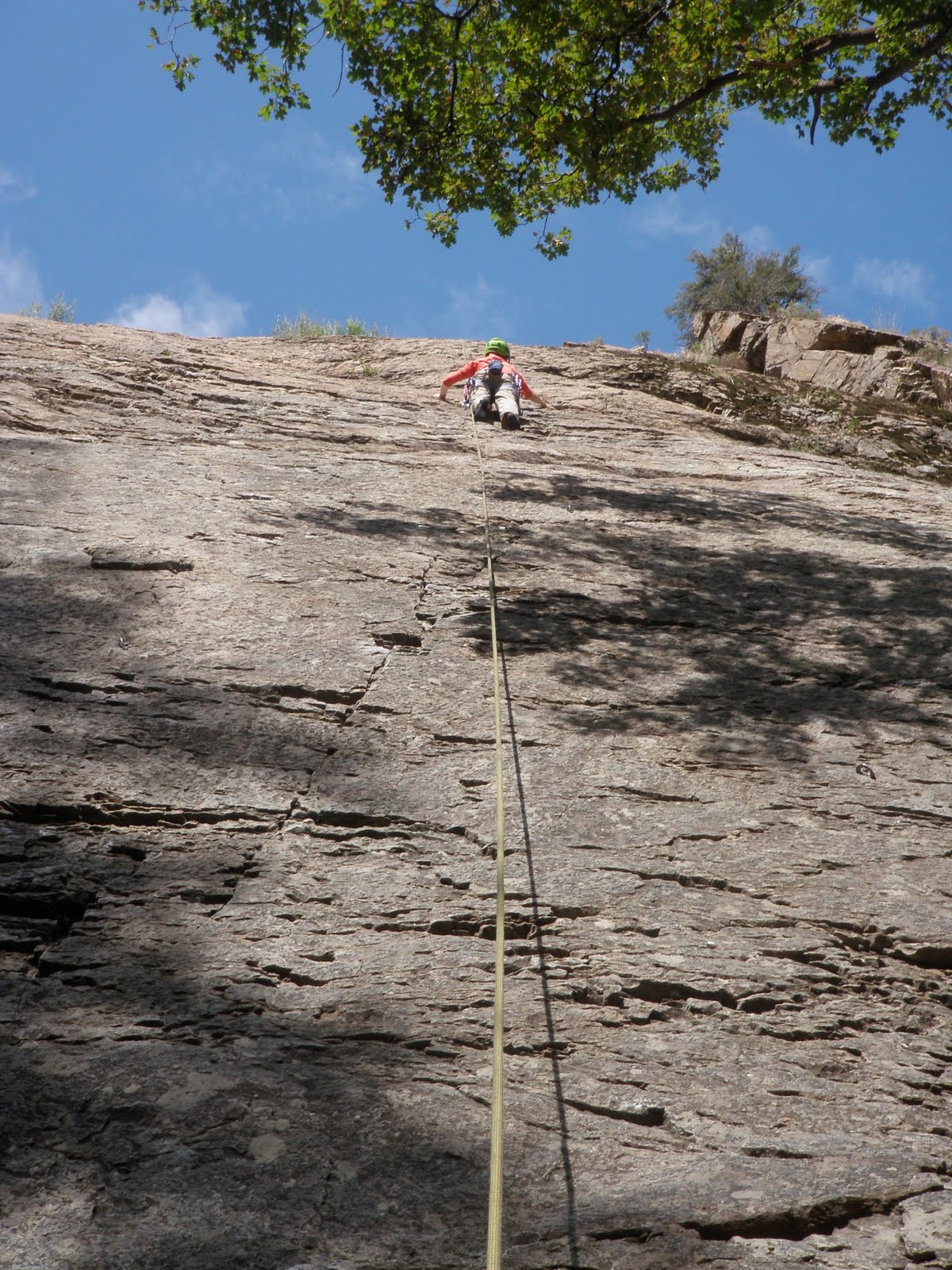
After topping out, we down climbed a short distance to a rappel tree and were soon at the base of the climb packing up our gear while another group of two started up the route. Our next climb was Glass Ocean, a bolted moderate on the Glass Ocean Wall, which was further uphill on the south side of the canyon above the Dead Snag Area. The hike was steep and loose with small rocks and boulders. Through many short switch backs we were standing at the base of the wall looking up to a group of two finishing a route. The wall looked fun and I looked forward to finding a route that would take us to the top since the Glass Ocean route only went halfway up. I consulted the guide book to see where the route went exactly. Were there two or three bolted routes on this part of the wall or not? Were we standing at the bottom of the 5.8 or the 5.10d? Still perplexed, I looked up at two bolts and decided they looked 5.8-ish and started up. The moves through those first two bolts were an edging wake up call. Definitely the hardest 5.8 I had climbed on this trip. Finally I was on top of an ample ledge 25 feet up heading straight up through more technical edging protected by bolts. Before another large ledge I pulled through a small roof, which was probably the easiest part of the climb. At the ledge above there was a set of anchors, but I thought the Glass Ocean anchors were farther to the right. Hm. Beth Ann lowered me to the ground and I looked at the guide book. Indeed, I had gone off route and had climbed the first pitch of Northwest Passage, a 5.10c. The first pitch seemed hardly 5.10, maybe 5.9, which gave me confidence that we could climb both pitches to the top. We waited for another group to rappel down the route we were about to climb, then I started up again to climb the pitch for the second time. I cleaned all the draws on the way up then topped out at the bolted anchors. Once there I started looking for the bolt line of the second pitch. In the book, I had seen that there was a gap between the first pitch anchors and the next bolt and the run out was over blocky terrain, which I assumed was easy. I did not see anything that looked immediately easy, but I did see a blocky crack a little to the right. I called down to Beth Ann to have her bring the trad rack up with her to protect the crack while I climbed higher looking for the next bolt. Beth Ann climbed up with the trad gear and we took a quick breather at the belay.

Beth Ann on the first pitch of Northwest Passage.
Photograph by Chuck Bolte.

From there I traversed right and up 10 feet to the start of the crack, which was much steeper than I thought it would be. The crack was tricky. It accepted medium cams extremely well in short parallel sections, but then flared wide making good jams hard to find. The face did not help much and I struggled to find good foot placements on the face or in the crack. I soon started to feel tired, out of my element, then pumped. I advanced a green cam up into a parallel section as far as I could and continued to climb. I could get my hands on a large sloping hold, but could not stand up. I was tired and getting desperate. My feet kept slipping on the blank face. I took a rest. It did not help. I went for the sloper again and my feet kept slipping. I was tired, I was done. I angrily wondered why the next bolt was so far away and why the terrain in between was so difficult. Then to my dismay I found that the highest cam, the green one, was so far in that I would need two hands to get it out and there were not good enough foot holds to use two hands. Thus began an insane process of placing cams to rescue the one cam. I had to place a cam above the green cam, weight the higher cam, reach both hands in and retrieve the green cam. Then I down climbed while moving cams below me for protection. Finally, back at the belay I was feeling defeated and cursing. It was decision time. We were at bolted anchors and could easily rappel, but I was certain we could find a way to the top, specifically up and to the left via a 5.9 crack. Wrong again. I was in a world of hurt 25 feet from the top, looking up a flaring crack, with pumped arms, and a shattered ego. Down and to my left I saw a bolt line that I could easily down climb to. We retreated from there. I was angry and defeated. The Glass Ocean Wall had confused me and broken my spirit. As I reached the bottom of the rappel I decided we would go ahead and climb the route Glass Ocean, the original destination, for redemption then leave. One day I would come back and redeem myself on Northwest Passage. One day. Glass Ocean was good redemption. Sustained 5.8 edging for a full pitch was good practice. Fried, as Beth Ann puts it, we hiked out, back to the truck and back to the city.

Monday, August 01, 2011

Journeys: SEND IT - August 1st - Salt Lake City, UT

The rain that started yesterday afternoon continued throughout today lasting until mid afternoon. I did some grocery shopping then Beth Ann and I hung around a Barnes and Nobles as the sky poured. Eventually we decided it would be best to go see the movie Cowboys and Aliens since climbing seemed out for the day. So we did, we saw it in XD. When we came out of the theater the rain had stopped, but the ground was still wet. We ventured up to Big Cottonwood Canyon and drove all the way up to Solitude. The resort was much greener and grassier than I had seen it in winter of 2008. I set a stop watch and the odometer to see how long and far it was back to Sugarhouse. 20.3 miles in 26 minutes. Not much shorter than my current commute to work, but I think working at a ski resort might be more enjoyable. Beth Ann and I sat around the house reading for some time before our host, Matt, came home. He was energized after a long day at the hospital and wanted to go for a trail run. I reluctantly joined him for a Currahee-like three miles up and three miles down cardio crushing fest in Mill Creek Canyon. The run took an hour and my left knee felt surprisingly good the whole time. Back home we cooked up a tasty shrimp and pasta dinner. The forecast for tomorrow looks great and we plan to knock out many climbs in Big Cottonwood Canyon.

Journeys: SEND IT - July 31st - Salt Lake City, UT

I woke thinking we would get rained out of our plans to climb the West Slabs of Mount Olympus. Rain was moving in for the afternoon and we got a late start to our climbing day. The approach to the climb started out of a neighborhood between Mill Creek and Big Cottonwood canyons and it was a bear. Gentle dirt switch backs quickly escalated to steep rock scrambling to the base of the route, which looked to be a wide low angle playground.

Looking up the approach gully.
Photograph by Chuck Bolte.

It looks so intimidating from the valley, but is so gentle up close. We broke into two parties; Beth Ann and I in one, Matt and Wendy in the other. Our plan was to climb three pitches then switch to simul-climbing for the much easier upper eight pitches of the climb. The climbing was fun and easy and provided a great view of the city and the entire valley. If I remember correctly we stuck to the middle of the slabs, which had little pro. I did not place a single piece of gear and belayed off suspect looking glue-in bolts.

Wendy and Matt on the first pitch.
Photograph by Chuck Bolte.

As we simul-climbed I worked harder to find pro and keep two pieces of gear between Beth Ann and I. The simul-climbing went quickly and soon enough, we topped out. We all sat down and ate some food while enjoying the view.

Matt looking south-ish.
Photograph by Chuck Bolte.

Then we noticed the rain coming in from the south and decided to get down as fast as we could. We rappelled once down the descent gully on the west ridge then scrambled down the rest of the way. After much downward trudging we were back on the easy dirt trail just as it started to sprinkle. As we pulled away in the car the rain came harder. We were just in time. We stopped at REI then got some pizza on the way home. Perfect. Tomorrow we have two or three trad routes picked out in Big Cottonwood Canyon as long as the rain holds off.