Monday, June 18, 2012

Journeys: Gallatin Peak - Day II

My alarm woke me up at 0400. The sky was still starry and black. I went back to sleep. My second alarm woke me up at 0430. My eyes fluttered open and I could see the western sky was still black. I rolled over and looked east. A crescent moon hung in deep blue skies just above and orange and yellow horizon. I had the idea that I was dreaming. I realized it was real and yelled at myself to get up and put my camera together to take photos. I took photos for the next hour and a half. It was a gorgeous secluded mountain sunrise.

Crescent moon and sunrise. Near Bear Basin.

I had to wear crampons to descend from the ridge into the basin. The snow was frozen and firm. I stopped at a stream in the basin to filter a few liters of water and ate breakfast. I continued through some trees and finally arrived at the base of the south face of Gallatin Peak. The slanted snow field I had chosen led up to a false summit. From there I would have to scramble 200 yards to the summit. I started up the snow field able to walk pied a plat 99 percent of the way. At the very top of the snow field the snow curled up to some rocks and I front pointed the last 10 feet of snow. I could see up to the summit and noted that it was a steep hike not even rock scrambling as expected. I looked down into the east bowl and immediately regretted hiking in from the North Fork trailhead. The east face snow field went from the base of the mountain to about 50 feet below the summit. I reckoned it would have been a more rewarding climb, but was happy to be up here. Maybe next time I will come in from Hellroaring trailhead and climb the east face.
Over the top and unnecessary hero pose - Gallatin Peak summit.
I slowly hiked up taking in all the scenery of the Spanish Peaks and beyond. I reached the summit and grinned. It was awesome. Soon the fattest chipmunk joined me and started nibbling at my pack. I took photos of the landscape then built a platform out of small rocks for my camera so that I could snap a self portrait. I hung around up top for a while eating and relaxing. I decided to explore the south ridge during my descent. I found that one could hike up picking their way around rock outcroppings and cliffs. From afar it looks to cliffed out to walk up. Back through the basin and up the other side to my camp where I had stashed unneeded gear. As I approached camp I spotted five or six big horn sheep euws traversing the ridge towards me. It seemed like that had no idea I was there, so I remained quiet and took a handful of terrible photos.

Fat chipmunk on Gallatin Peak.
Big horn sheep ewe above Bear Basin.
I took another long break at camp while I packed my gear and ate lunch. I descended from the ridge looking for safe snow to glissade on, but had no luck. I was in the bottom of Bear Basin and had six miles ahead of me. I hung my head and ground it out. I was exhausted. When I reached the trailhead parking lot and my truck I slumped to the ground my back against a tire. I wondered if I felt a tenth as tired as mountaineers coming off of a Himalayan summit.

Falls in Bear Basin.
Route up Gallatin Peak.


Friday, June 15, 2012

Journeys: Gallatin Peak - Day I


Still in search of snow climbs, I set my sights on Gallatin Peak. I had seen a large snow field on the east face from Wilson Peak and decided to do an over night backpacking trip to climb it. I struck out from the North Fork trailhead late in the afternoon with a heavy pack. I covered the first three miles in one hour. I covered the next three miles into Bear Basin in three hours. Getting up into Bear Basin takes more than a few switch backs over steep ground. Once in Bear Basin the terrain flattened, but I hit the snow line and travel was slow in the slush even with snowshoes. I reached the back of Bear Basin hoping to find clues of the trail heading up over the ridge to the northeast and through a pass into the basin south of Gallatin Peak. I found no clues. Instead I struggled, slipping and crawling, through wet snow up a steep rocky gully. I was spitting mad and tired. 

Near the top of the crest of the ridge I left the snow line and took my snowshoes off. I saw the trail ahead of me and followed it up onto the ridge. It was already after 8 p.m., I was tired, and from the ridge I saw that I had made a crucial mistake. To get to the east face of Gallatin Peak I would have to descend into the basin then hike three to four miles around Gallatin Peak's southeast ridge in order to get to the east face. I did not feel the need to push on through the dark and found a flat spot on the ridge to camp. As I ate dinner I picked a new route up a snowfield on the south east face of the peak. The sun was setting behind the head of Bear Basin. 

Shadows lengthened and the temperature dropped. I hoped that even in mid-June my zero degree bag would keep me warm through the night at close to 10,000 feet. I finished dinner and the sky was an inky blue and black. Near the zenith was Hercules and not far away the Big Dipper. I crawled into my sleeping bag and found the bivy sack coated with frost. I set my camera tripod up beside me in hopes of catching a nice sun rise in the morning and fell into a fitful sleep.

Thursday, June 14, 2012

Journeys: Beehive Peak II


Today I returned to Beehive Peak to search for an easier route to the summit from the 4th of July Couloir col. I camped in my redneck RV at the trailhead and got an alpine start, hiking before the sun woke up. The snow throughout the basin was firm and frozen and I did not need my snowshoes. At the 4th of July Couloir I strapped on my crampons and dug the spikes into the frozen snow. Climbing on the firm went much faster than the slush two days ago. Near the col I looked down and saw two snowboarders hiking up the basin. I passed the narrow couloir I climbed previously then went to the other side of the col and looked at a wider couloir. The second couloir was much wider and only had a short steep section in the middle. I was confident I could climb this couloir and find a way to the summit. 

The "easier" couloir.
Again the climbing was fast on the frozen snow and I front pointed up quickly until I reached a familiar rock section below the summit. I found my previous path and climbed to the summit. From the top I watched the snowboarders climbing on the east ridge while I snacked on trail mix. I wanted to descend before the snow softened and soon left the summit. I retraced my steps through the couloir and to the bottom of the 4th of July. The snowboarders were riding down from the east ridge and pulled up to stop at the bottom of 4th of July. I asked if I they were going to ride the couloir and if I could take photos. Their names were Addison and Mike and they agreed to some photography. We all hiked out and I went to work.

Addison Sponsler - shredding.
Mike Hudik - ripping.

Tuesday, June 12, 2012

Journeys: Beehive Peak


I climbed Beehive Peak today. Sometimes when you climb to the top of crag or a mountain you feel like you have conquered it. Today was not one of those days. Today felt like the mountain let me off the hook...this time.

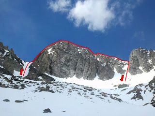
Traverse over Beehive Peak.
I should have camped at the trailhead and got a proper alpine start. Instead I arrived hours late and started hiking up Beehive Basin just after 7 a.m. One mile in I saw a moose and her calf grazing on a grassy slope. No bears. Shortly after the moose I hit the snow line and put on my snowshoes. An hour and a half later I was in the bowl below Beehive Peak putting on my crampons. The snow was too soft for crampons, but I needed the practice. I cached my snowshoes and trekking poles under a small tree then started up the 4th of July Couloir, ice axe in hand. Climbing in the soft snow was slow and tiring. I am not sure how long it took to climb the couloir, but the view from the top was fantastic. I could see where someone had skied down the backside toward Beehive and Spanish Lakes. There may have been two or three small couloirs leading from the col to the summit of Beehive Peak, but I did not take time to assess each of them. I started climbing the one in front of me. It was a tight and steep couloir that tapered to what looked like (hopefully) 4th class rock.

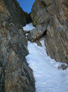
Couloir above 4th of July Couloir.
The first few steps up were fine, but I was soon swimming in thigh deep sugar with my crampons bottoming out on rock. I was not comfortable with this and should have turned back, but stubbornly pressed on. The snow ended and I reached the 4th class rock. A rope and a partner would have been nice, but the crampon's spikes were quite stable on the rock and I climbed up passing a rat's nest of rappel anchors on the way.

I could see the peak. In between was snow and more 4th class scrambling. I started crossing the snow headed for the rock and realized I had left one couloir for the top of another larger one. I looked down the couloir and realized that I was now in a no fall zone with a fatal runout. The bottom of the couloir ended in thin air and the valley floor below. I made my way to the base of the 4th class scramble to the summit and removed my crampons. I had tried two different routes turning back when the moves were too committing before finding an easy route to the summit on the third try. The view from the summit was beautiful. To the north was Gallatin Peak, to the east Wilson Peak, and to the south Lone Peak and Fan Mountain. I spent a while eating and taking photos from the summit then packed up to head down the east ridge. I had heard that the east ridge was exposed 3rd class rock scrambling.
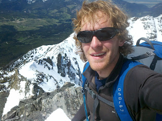
On the summit.
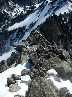
Looking at the ridge traverse from the summit. 
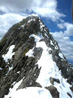
Looking back at the ridge traverse after finishing.
In snow it was treacherous. The sheer cliffs hundreds of feet down either side did not help my nerves, but I grit my teeth and made it to the descent gully below Honeycomb Peak. The descent gully was a gentle relief to the ridge traverse. Back in the bowl below Beehive Peak I took a long break and collected my nerves then made the hike back to the trailhead and my truck. As glad as I was to be out of a dangerous situation and finished with the climb I had a strong desire to go back for another round and see if I could find and easier way to the summit.

Friday, June 08, 2012

Journeys: Wilson Peak


I got my late alpine start for Wilson Peak and was hiking at 0655 from the North Fork Trailhead. Approximately 1.5 miles up the trail I crossed the National Forest boundary and immediately left the trail. I walked north and crossed the creek then picked up an unmapped trail up a spur into the drainage northwest of Yellow Mountain. I followed the trail past two rock outcroppings about 200 yards apart. The side hill was steep. I should have crossed the creek at the second rock outcropping, but crossed further up after the side hilling became extremely steep. Shortly I was in a clearing and could see directly up the barren avalanche slide path to the southwest face of Wilson Peak. 

Wilson Peak from the clearing.

I continued to follow the stream straight up the southwest face, which became extremely steep. Maybe 300 yards from the summit a whiteout snowstorm enveloped the mountain. I reached the summit in just under three hours. I took photos from the peak and then explored the saddle to the east that Kaya, Tanner, and I had seen a few days before. Unable to cross a large frozen snow field in the saddle, I backtracked to the West. I traversed out the ridge to another mountaintop at 10,3000-ish feet and took a break for photos and lunch. 


Pioneer Mountain, Cedar Mountain, Lone Peak, and Fan Mountain (L to R).

From this point I could see everything. Beehive Basin and Beehive Peak, Middle Basin, Bear Basin, Gallatin Peak, Hell Roaring Creek, Table Mountain, Wilson Peak, Taylor Peaks, The Sphinx, The Helmet, and Fan Mountain. I finished lunch and started my descent into Bear Basin. I followed slushy snow fields and glissaded as much as possible to save time and energy. I reached the stream under Mount Chipperfield and crossed it then picked up the trail on the other side. Three to four miles later of great single track brought me back to the trailhead. I relaxed for quite a while in my truck then went to work.


Looking back at Wilson Peak during the descent.